Bonfires in and around Glasgow have had a very negative impact on the environment this year
Bonfires ‘increased air pollution’ on 2017’s coldest autumn night so far
Share
Bonfires in and around Glasgow have had a very negative impact on the environment this year
The remnants of bonfires and fireworks are likely to have increased air pollution across Glasgow and its surrounding areas on Monday.
The Highlands, Central Scotland and the Scottish Borders all recorded “high” levels of pollution, probably owing to Guy Fawkes Night celebrations, the Department for Environment, Food and Rural Affairs (Defra) said.
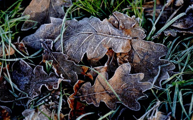
Leaves covered in frost near Ashford, Kent (Gareth Fuller/PA)
Defra said they were likely to have been elevated “due to their proximity to bonfire and firework displays last night”.
This was likely to clear by the end of Monday, and generally low levels are forecast for much of the UK on Tuesday, the department added.
November 5 was the coldest night of autumn this year, with Glasgow and its surrounding areas waking up to frost-covered cars and icy dew lining fields and trees.
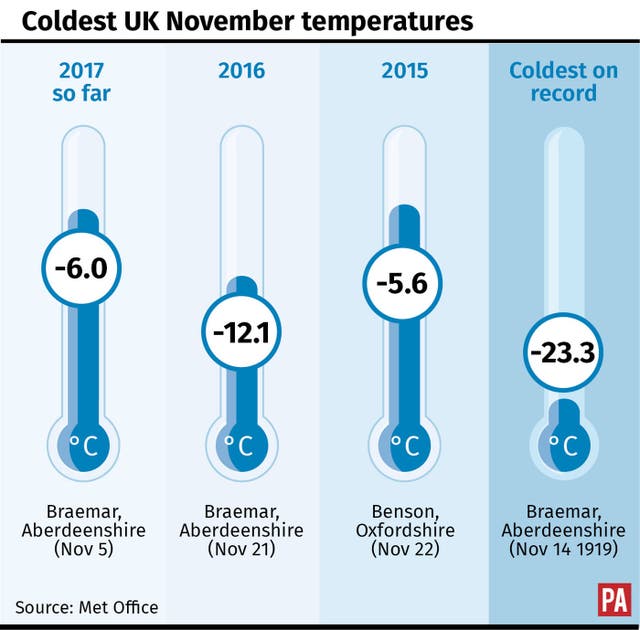
A temperature of minus 6C (21.2F) was recorded in Braemar, Aberdeenshire – but that still lagged behind the coldest night of 2017 so far, when minus 10.1C (13.8F) was recorded on January 30 in the same place.
(PA Graphics)
It is still some way off the coldest November temperature of last year, when minus 12.1C (10.2F) was registered, again in Braemar.
A largely cloudless night allowed heat to escape, “leading to the widespread frost”, Met Office forecaster Oli Claydon said.
Most of the UK will remain largely bright and chilly for the rest of the week, with highs of around 10C to 12C (50F to 53.6F), he added.
But clouds, wind and rain will be felt across parts of Scotland and the far North West, according to the Met Office forecast.
The band of rain and wind will then move slowly south east, pulling cooler air with it.
Frosty conditions may be seen, particularly in central areas, Mr Claydon added.
Wednesday and Thursday will remain largely dry in the South and South East, but rain is likely to persist in the North West.
Mr Claydon said: “The slow-moving cold front is spinning off a low-pressure system. As we move closer to the weekend the system starts to pull cooler air from the North West down, bringing a cooler feel.
“It’s also responsible for the showery set-up we’re likely to see on Friday.
“Then there will be fairly widespread blustery cold showers across the UK with periods of brightness mixed in.”
It is too early to predict confidently what conditions will be like from Sunday onwards, the Met Office added.
Share
Comments & Moderation
Readers’ comments: You are personally liable for the content of any comments you upload to this website, so please act responsibly. We do not pre-moderate or monitor readers’ comments appearing on our websites, but we do post-moderate in response to complaints we receive or otherwise when a potential problem comes to our attention. You can make a complaint by using the ‘report this post’ link . We may then apply our discretion under the user terms to amend or delete comments.
Post moderation is undertaken full-time 9am-6pm on weekdays, and on a part-time basis outwith those hours.

 Leaves covered in frost near Ashford, Kent (Gareth Fuller/PA)
 (PA Graphics)


Comments & Moderation
Readers’ comments: You are personally liable for the content of any comments you upload to this website, so please act responsibly. We do not pre-moderate or monitor readers’ comments appearing on our websites, but we do post-moderate in response to complaints we receive or otherwise when a potential problem comes to our attention. You can make a complaint by using the ‘report this post’ link . We may then apply our discretion under the user terms to amend or delete comments.
Post moderation is undertaken full-time 9am-6pm on weekdays, and on a part-time basis outwith those hours.
Read the rules here